Topography
Topography is the study of the Earth’s surface features. It is a multidisciplinary field that looks at and maps landscapes, changes in elevation, and other physical factors that make up the Earth’s surface. This study goes into great detail about the terrain, explaining what it means, how to analyze it, and how important it is for understanding our planet.
Definition and Significance of Topography:
Topography, derived from the Greek words “topos” (place) and “graphia” (writing), collectively translates to “the writing of place.” It is the science of depicting the physical features of a region or surface, providing a detailed representation of the Earth’s terrain.
Understanding topography is paramount for a myriad of scientific disciplines, including geology, geography, hydrology, and environmental science, as it forms the basis for land use planning, resource management, and disaster risk assessment.
Methods of Topographic Measurement:
Several methods are employed to measure and represent topography, each catering to specific scales and resolutions. These include:
Surveying: Traditional land surveying methods involve the use of instruments such as theodolites and total stations to measure angles and distances, providing accurate data for small to medium-sized areas.
Remote Sensing: Satellite and aerial imagery, obtained through remote sensing technologies, offer a broader perspective and are crucial for large-scale mapping and monitoring of changes in the Earth’s surface.
Global Positioning System (GPS): GPS technology enables precise positioning of points on the Earth’s surface, facilitating accurate mapping and navigation.
LiDAR (Light Detection and Ranging): LiDAR systems use laser beams to measure distances, creating highly detailed three-dimensional maps. This technology is particularly effective for capturing the topography of dense vegetation and urban areas.
Representation of Topographic Maps:
Topographic maps serve as the primary tool for representing the Earth’s surface features. These maps employ contour lines, which connect points of equal elevation, providing a visual representation of the landscape’s relief.
Contour intervals, the vertical distance between contour lines, dictate the level of detail on the map. Supplementary information such as scale, legend, and symbols enhances the map’s interpretability.
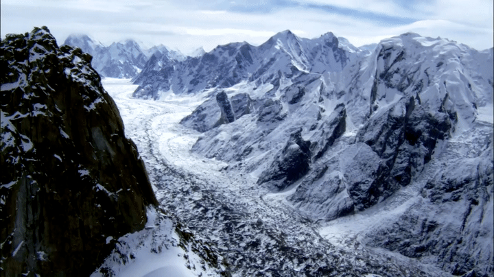
Landforms and Features:
Topography encompasses a diverse range of landforms, each shaped by geological processes over time. These include:
Mountains: Elevated landforms are typically formed by tectonic activity or volcanic processes.
Valleys: depressions between elevated areas, often carved by rivers or glaciers.
Plateaus: elevated flatlands, the result of geological uplift or volcanic activity.
Plains: broad expanses of relatively flat land, often fertile and suitable for agriculture.
Rivers and lakes are dynamic water features that significantly influence the topography of an area.
Digital Elevation Models (DEMs):
Digital Elevation Models are digital representations of the Earth’s surface, created through the analysis of elevation data collected from various sources. DEMs provide a three-dimensional perspective, allowing for the visualization and analysis of terrain features.
Advanced GIS (Geographic Information System) technologies enable the integration of various data layers, enhancing our ability to study topography comprehensively.
Geomorphic Processes and Topography:
Geomorphic processes like weathering, erosion, and deposition continually shape the Earth’s surface. These processes, often influenced by geological forces, climate, and human activities, contribute to the dynamic nature of topography. Studying these interactions is essential for predicting landscape changes, managing natural resources, and mitigating the impact of natural disasters.
Applications of Topography:
Topography plays a crucial role in various fields and applications.
Urban Planning: Understanding the topography of urban areas aids in infrastructure development, zoning, and disaster resilience planning.
Environmental Monitoring: Topographic maps and models are utilized to assess changes in ecosystems, track deforestation, and monitor land-use changes.
Civil Engineering: Engineers rely on topographic data for designing infrastructure such as roads, bridges, and drainage systems.
Natural Resource Management: Agriculture, forestry, and mining industries utilize topography to optimize land use and resource extraction.
Challenges in Topography:
Despite technological advancements, challenges in topography persist, including the need for accurate and up-to-date data, especially in rapidly changing environments. Addressing these challenges requires ongoing research and the integration of emerging technologies.
Future Trends and Innovations:
Advancements in satellite technology, artificial intelligence, and machine learning are revolutionizing topography. These innovations promise to enhance the accuracy and efficiency of data collection and analysis, opening new possibilities for understanding and managing the Earth’s surface.
The study of topography is an important way to understand the Earth’s surface, its features, and the changing forces that shape it. Topography research, from old-fashioned surveying methods to cutting-edge technologies, not only helps us learn more about science, but also gives us the information we need to make smart choices about how to use land, handle resources, and protect the environment. Even though our methods and tools are always getting better, the field of topography is still very important for dealing with the problems and chances that come up because our planet is always changing.