GLACIERS
Up to a third of Earth’s surface has been blanketed with glacial ice at various points in the past. Around 10,000 years ago, the last of the North American ice sheets melted. The destruction, transportation, and deposition of massive amounts of rock and silt caused by the passage of glaciers across the continents drastically transformed the landscape.
Glaciers not only eroded enormous areas down to flat bedrock surfaces, but they also molded some of the remarkable erosion structures in the high mountain ranges. Some of the broad, gently undulating landscapes we see today, such as in southern Wisconsin, were produced by the deposition of glacial sediments.
To put it simply, glaciers are massive, snaking bodies of ice that form on land during periods of lower average temperatures. If more snow falls than is lost to melting throughout the year, a glacier will begin to expand. As more snow accumulates on top, the older snow beneath it compacts, recrystallizes, and eventually freezes. Once a glacier has gained enough mass, gravity will start to pull it down the mountain.
The process by which an ice sheet advances across the earth is called glaciation. Continental and alpine glaciation are the two main categories of this phenomenon. A large swath of a continent, like Antarctica, is affected by continental glaciation. In the Alps, the glacier is typically confined to steep valleys at high altitudes.
In the early 1800s, Swiss scientist Louis Agassiz advanced the hypothesis that, in the geologic past, substantially more of the planet was covered by glaciers than we see now. As a corollary, this idea, called the “theory of glacial ages,” implied that colder climates had persisted for eons. In the past several million years, Earth has had a number of glacial periods interspersed with warmer temperate periods. The fertile agriculture of the Midwest in the United States is the result of glaciers moving dirt from the northern section of North America (Canada) and depositing it further south.
Types of Glaciers
Both arctic and temperate regions have glaciers. The arctic areas, where temperatures rarely get above freezing, are home to the greatest number of these creatures. They can also be found in the highest mountains in temperate or even tropical latitudes where temperatures remain cold throughout the year, such as in the Pacific Northwest of the United States and Canada, Alaska, and South America. More snow and ice accumulate throughout the winter months in these mountain ranges than is lost as meltwater in the summer.
Today, glaciers encompass approximately 10% of the Earth’s land area. Over 75 percent of this amount is in Antarctica, and 10 percent is on Greenland. The remainder is found in various mountainous areas worldwide. Many low-lying coastal communities throughout the world would be inundated if the entire Antarctic ice sheet melted, which would raise sea levels by around 60 meters (200 feet).
Large, land-covering ice sheets are typically linked with continental glaciation (over tens of thousands of square kilometers). The polar regions of Greenland and Antarctica both have extensive ice sheets. A smaller version of ice sheets, icecaps can be found where the snowfall is the heaviest in mountains. Multiple valley glaciers may have their origin in a single ice cap.
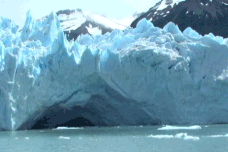
Glaciers that can only be found in mountain valleys are called valley glaciers or alpine glaciers. Larger valley glaciers can be joined as they migrate downslope. Valley glaciers advance and recede repeatedly, causing most alpine glaciation. Most mountain ranges in the United States and Canada feature valley glaciers. Where the ice first emerges at the front of a mountain range is where piedmont glaciers originate, representing the most extreme extension of valley glaciers. At the valley’s edge, the ice has stretched out to form a broadsheet on the level ground.
Glacialization of North America
The northern three-quarters of the United States and all of Canada were affected by the final major glaciations in North America during the Pleistocene. The ice sheet’s thickest and most central section covered Hudson Bay. The ice sheet wiped off Canada’s topsoil, smoothed out the bedrock, and carved out a number of future lake basins. Fertile farmlands in the United States were formed as till and outwash were deposited to the south. The Great Lakes basins are surrounded by end moraines, which the glaciers created. There were several glacial lakes in the prairies of Canada, North Dakota, and Minnesota. After the main ice sheet melted away, alpine glaciers persisted in California, the Rocky Mountains, and the northern Appalachians.
Because of the massive ice sheet, sea levels dropped by around 130 meters (430 feet). Undersea fossils of land animals, such as mammoths, have been discovered on continental shelves, providing evidence in this direction. Rising sea levels can be attributed in part to the melting of glaciers, which added water to the oceans. A fiord is a narrow coastal inlet with steep walls and the shape of a finger. Fiords were formed when glaciers retreated and the land was submerged by the sea.
Wetter conditions existed during and after glacial retreat, and it was during these times that pluvial lakes formed. The Great Salt Lake in Utah, for instance, is all that’s left of a formerly massive pluvial lake. More dry circumstances have persisted since most pluvial lakes developed, causing them to shrink.
Glacial ice can put a great amount of pressure on the earth’s crust, possibly causing it to sink more than 200 meters. When glaciers melt away, the crust gradually rises to its original height. The area around the Great Lakes in the United States is still seeing this crustal rebound.
Permeability
The term “permeability” is used to describe how easily fluid may move through a rock’s pore space. It’s possible for a rock to have a high porosity without having a high permeability. The permeability of a rock or sediment is a function of the connectivity of its pores. Sandstone is often permeable and has a high porosity. Although shale is porous, its permeability is reduced due to its tiny particle size. Unless severely broken through tectonic processes, igneous rocks have poor porosity and permeability.